Search all 98 Metrorail stations, turn individual lines on or off, and plan a trip between any two stations to see which trains to take, where to transfer and how many stops it is. Line routes and station positions follow the real geography of Washington, Maryland and Virginia.
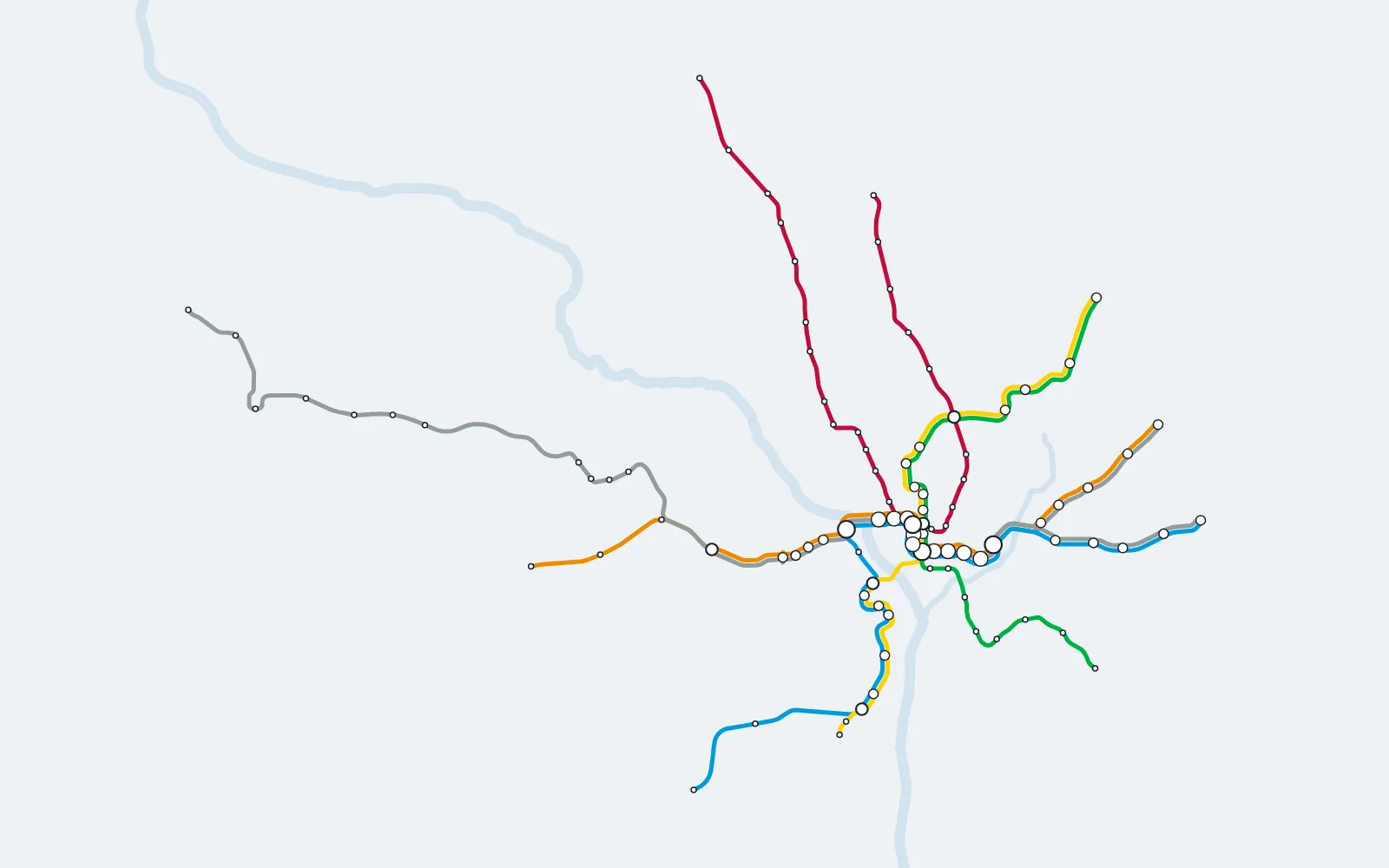
The interactive map needs JavaScript. The full station lists for every line are below the map.
Explore Washington DC Metro Lines
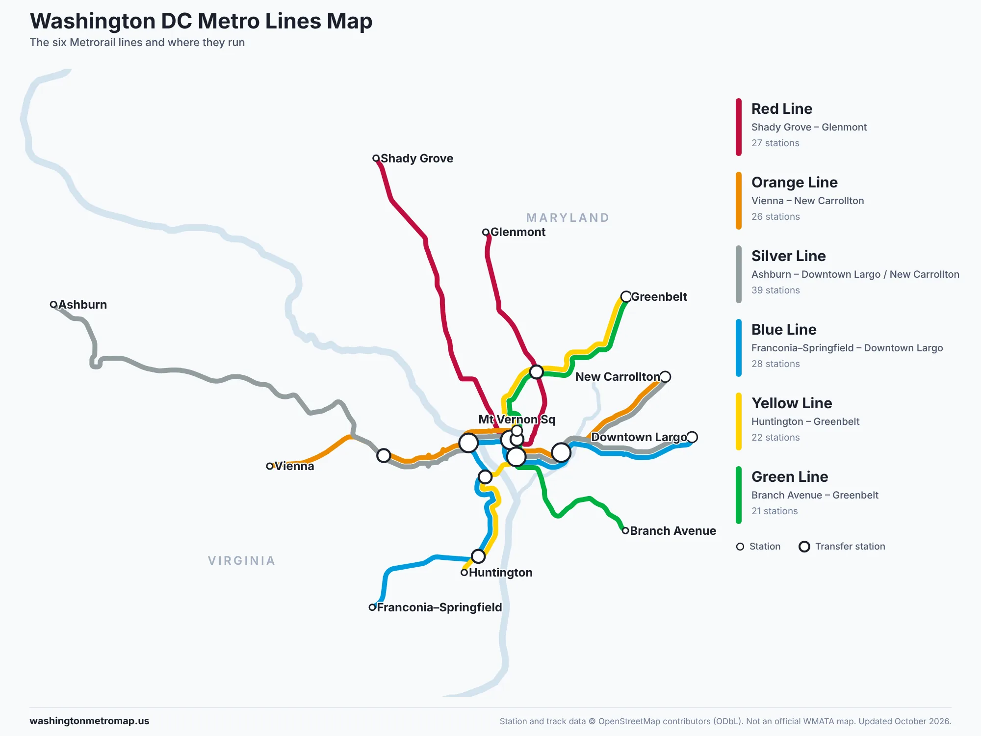
Metrorail has six color-coded lines. Each one is listed below with its end stations, every stop in order, and an original map of its route. Select a station name to show it on the interactive map.
- Red LineShady Grove – Glenmont
- Orange LineVienna – New Carrollton
- Silver LineAshburn – Downtown Largo / New Carrollton
- Blue LineFranconia–Springfield – Downtown Largo
- Yellow LineHuntington – Greenbelt
- Green LineBranch Avenue – Greenbelt
Red Line: Shady Grove to Glenmont
The Red Line runs in a U shape from Shady Grove in Montgomery County, through downtown Washington, and back out to Glenmont. It is the only Metrorail line that does not share its tracks with another line. The Red Line serves 27 stations. Transfer stations: Metro Center, Gallery Place, and Fort Totten.
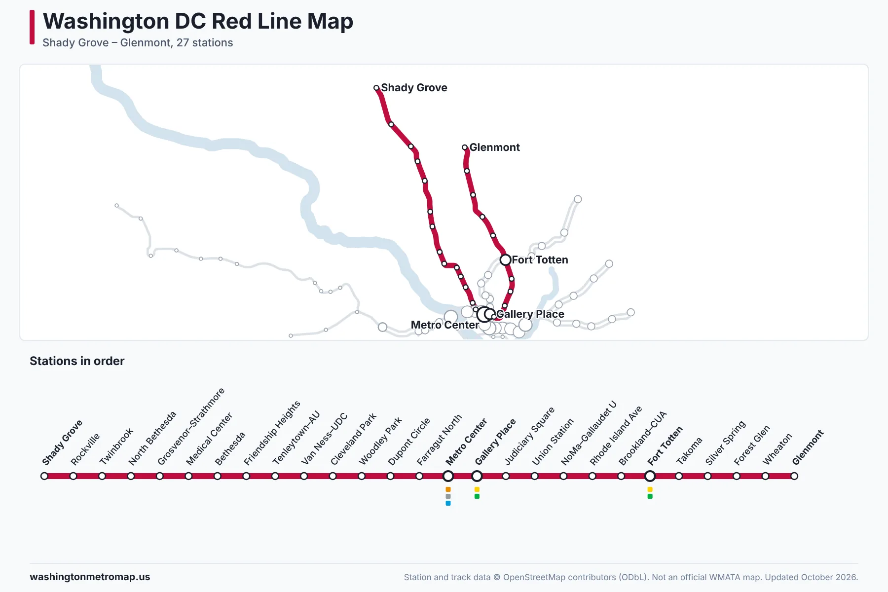
- Shady Grove
- Rockville
- Twinbrook
- North Bethesda
- Grosvenor–Strathmore
- Medical Center
- Bethesda
- Friendship Heights
- Tenleytown–AU
- Van Ness–UDC
- Cleveland Park
- Woodley Park
- Dupont Circle
- Farragut North
- Metro Center (Orange, Silver, Blue)
- Gallery Place (Yellow, Green)
- Judiciary Square
- Union Station
- NoMa–Gallaudet U
- Rhode Island Ave–Brentwood
- Brookland–CUA
- Fort Totten (Yellow, Green)
- Takoma
- Silver Spring
- Forest Glen
- Wheaton
- Glenmont
Orange Line: Vienna to New Carrollton
The Orange Line connects Vienna in Fairfax County with New Carrollton in Prince George's County, crossing the Potomac between Rosslyn and Foggy Bottom. Through Arlington and downtown it shares tracks with the Silver Line, and with the Blue Line east of Rosslyn. The Orange Line serves 26 stations. Transfer stations: East Falls Church, Rosslyn, Metro Center, L'Enfant Plaza, and Stadium–Armory.
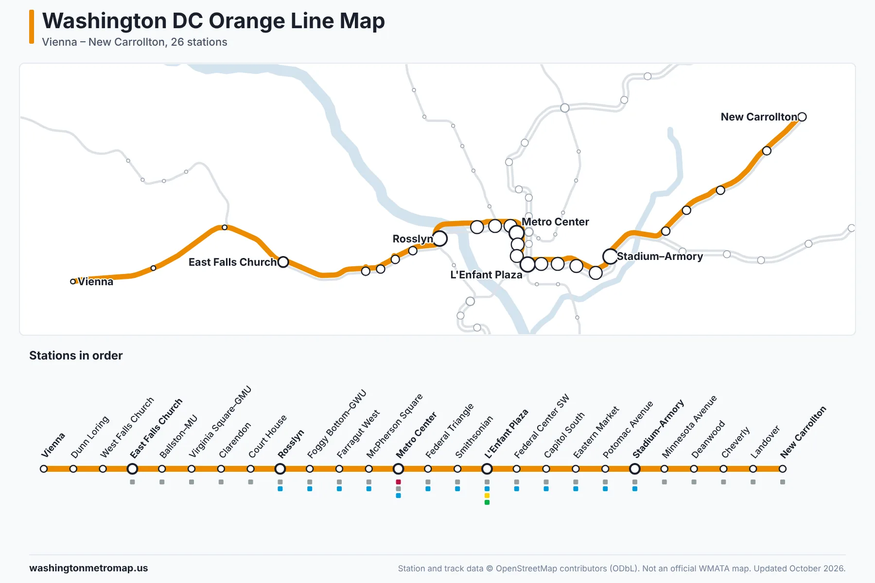
- Vienna
- Dunn Loring
- West Falls Church
- East Falls Church (Silver)
- Ballston–MU (Silver)
- Virginia Square–GMU (Silver)
- Clarendon (Silver)
- Court House (Silver)
- Rosslyn (Silver, Blue)
- Foggy Bottom–GWU (Silver, Blue)
- Farragut West (Silver, Blue)
- McPherson Square (Silver, Blue)
- Metro Center (Red, Silver, Blue)
- Federal Triangle (Silver, Blue)
- Smithsonian (Silver, Blue)
- L'Enfant Plaza (Silver, Blue, Yellow, Green)
- Federal Center SW (Silver, Blue)
- Capitol South (Silver, Blue)
- Eastern Market (Silver, Blue)
- Potomac Avenue (Silver, Blue)
- Stadium–Armory (Silver, Blue)
- Minnesota Avenue (Silver)
- Deanwood (Silver)
- Cheverly (Silver)
- Landover (Silver)
- New Carrollton (Silver)
Silver Line: Ashburn to Downtown Largo
The Silver Line starts at Ashburn in Loudoun County and serves Washington Dulles International Airport, Reston and Tysons before joining the Orange Line at East Falls Church. East of Stadium–Armory, trains continue either to Downtown Largo or to New Carrollton, so check the destination sign before boarding. The Silver Line serves 39 stations. Transfer stations: East Falls Church, Rosslyn, Metro Center, L'Enfant Plaza, and Stadium–Armory.
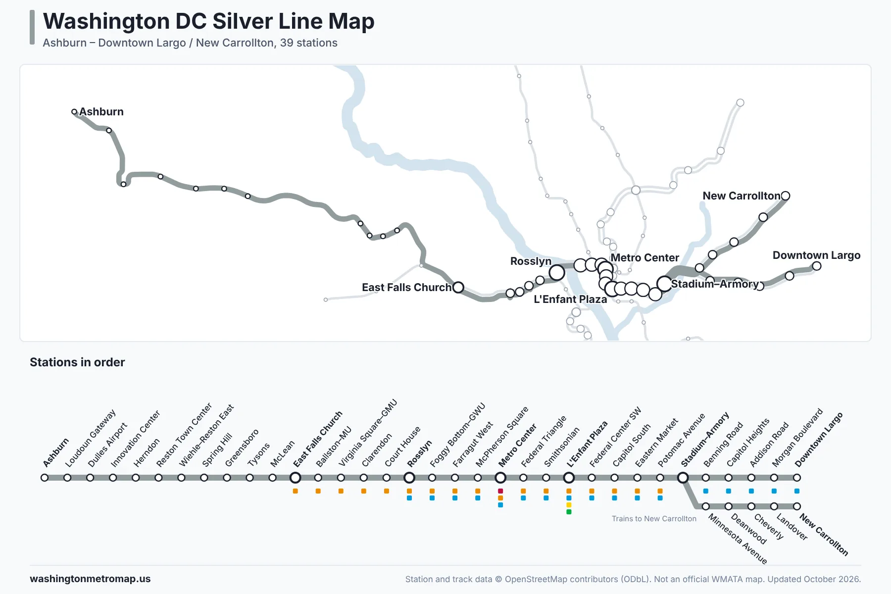
- Ashburn
- Loudoun Gateway
- Washington Dulles International Airport
- Innovation Center
- Herndon
- Reston Town Center
- Wiehle–Reston East
- Spring Hill
- Greensboro
- Tysons
- McLean
- East Falls Church (Orange)
- Ballston–MU (Orange)
- Virginia Square–GMU (Orange)
- Clarendon (Orange)
- Court House (Orange)
- Rosslyn (Orange, Blue)
- Foggy Bottom–GWU (Orange, Blue)
- Farragut West (Orange, Blue)
- McPherson Square (Orange, Blue)
- Metro Center (Red, Orange, Blue)
- Federal Triangle (Orange, Blue)
- Smithsonian (Orange, Blue)
- L'Enfant Plaza (Orange, Blue, Yellow, Green)
- Federal Center SW (Orange, Blue)
- Capitol South (Orange, Blue)
- Eastern Market (Orange, Blue)
- Potomac Avenue (Orange, Blue)
- Stadium–Armory (Orange, Blue)
- Benning Road (Blue)
- Capitol Heights (Blue)
- Addison Road (Blue)
- Morgan Boulevard (Blue)
- Downtown Largo (Blue)
Trains to New Carrollton continue from Stadium–Armory to:
- Minnesota Avenue (Orange)
- Deanwood (Orange)
- Cheverly (Orange)
- Landover (Orange)
- New Carrollton (Orange)
Blue Line: Franconia–Springfield to Downtown Largo
The Blue Line runs from Franconia–Springfield through Alexandria, Ronald Reagan Washington National Airport, the Pentagon and Arlington Cemetery, then crosses into downtown at Rosslyn and continues to Downtown Largo. The Blue Line serves 28 stations. Transfer stations: King Street–Old Town, Pentagon, Rosslyn, Metro Center, L'Enfant Plaza, and Stadium–Armory.
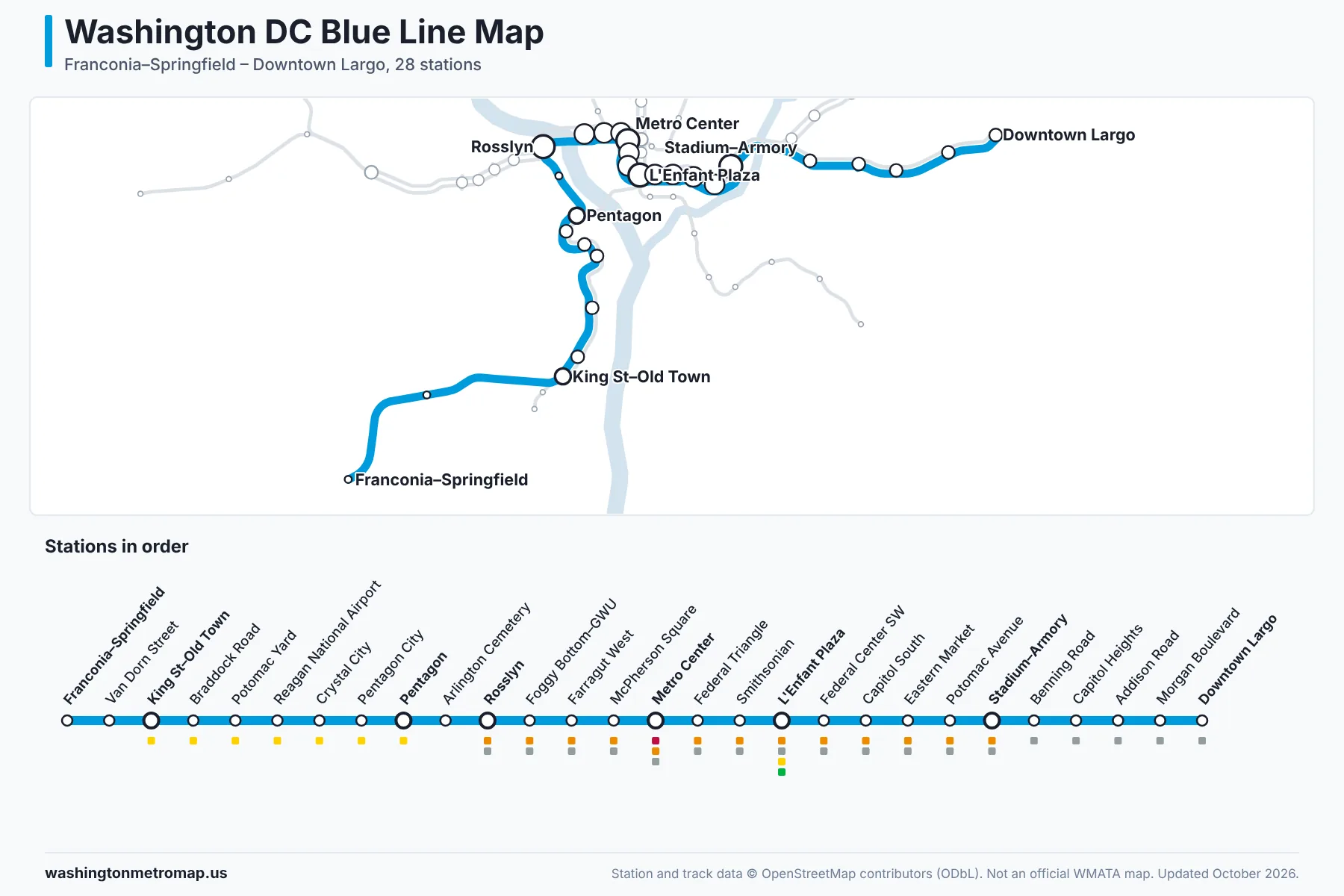
- Franconia–Springfield
- Van Dorn Street
- King Street–Old Town (Yellow)
- Braddock Road (Yellow)
- Potomac Yard (Yellow)
- Ronald Reagan Washington National Airport (Yellow)
- Crystal City (Yellow)
- Pentagon City (Yellow)
- Pentagon (Yellow)
- Arlington Cemetery
- Rosslyn (Orange, Silver)
- Foggy Bottom–GWU (Orange, Silver)
- Farragut West (Orange, Silver)
- McPherson Square (Orange, Silver)
- Metro Center (Red, Orange, Silver)
- Federal Triangle (Orange, Silver)
- Smithsonian (Orange, Silver)
- L'Enfant Plaza (Orange, Silver, Yellow, Green)
- Federal Center SW (Orange, Silver)
- Capitol South (Orange, Silver)
- Eastern Market (Orange, Silver)
- Potomac Avenue (Orange, Silver)
- Stadium–Armory (Orange, Silver)
- Benning Road (Silver)
- Capitol Heights (Silver)
- Addison Road (Silver)
- Morgan Boulevard (Silver)
- Downtown Largo (Silver)
Yellow Line: Huntington to Greenbelt
The Yellow Line shares tracks with the Blue Line from Huntington and King Street–Old Town to the Pentagon, then crosses the Potomac on its own bridge to L'Enfant Plaza. Some trains end at Mt Vernon Sq; trains signed Greenbelt continue north alongside the Green Line. The Yellow Line serves 22 stations. Transfer stations: King Street–Old Town, Pentagon, L'Enfant Plaza, Gallery Place, and Fort Totten.
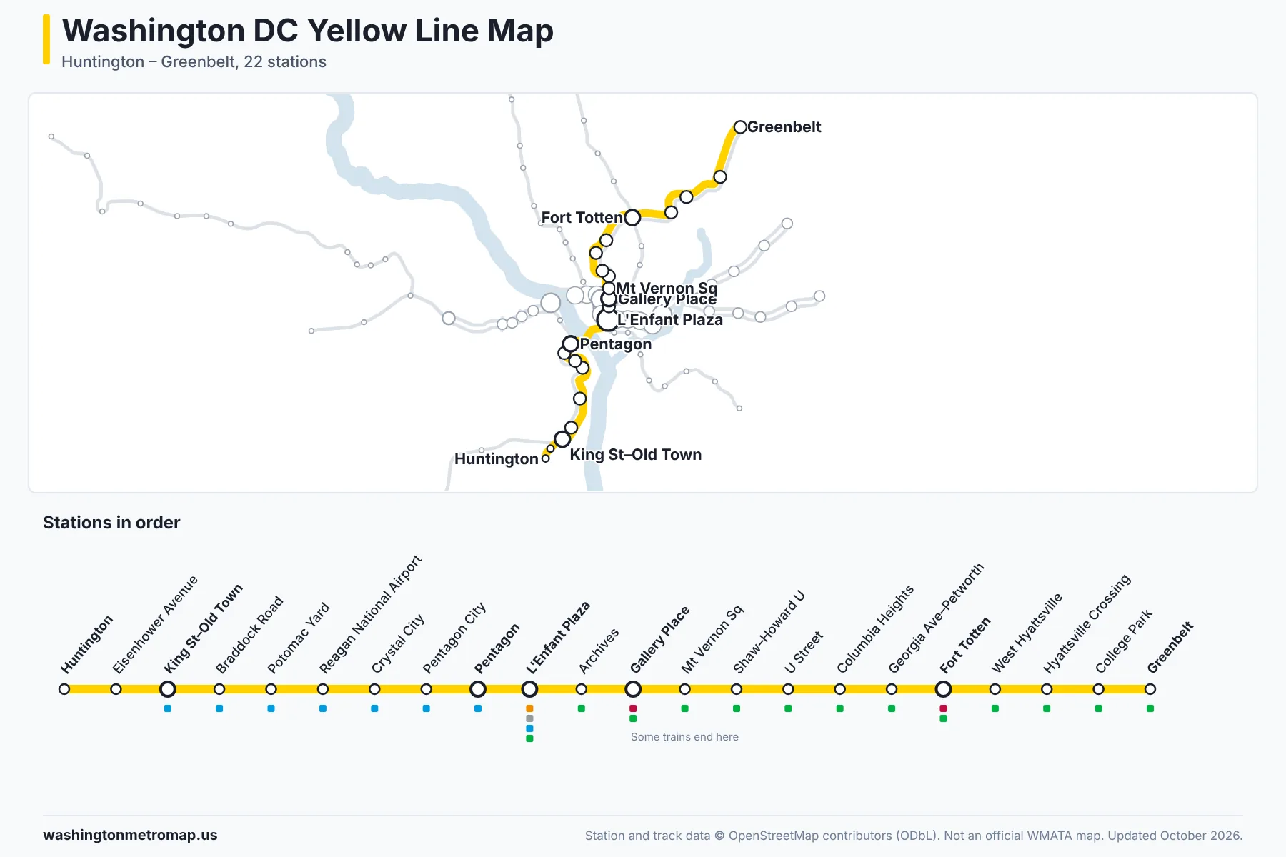
- Huntington
- Eisenhower Avenue
- King Street–Old Town (Blue)
- Braddock Road (Blue)
- Potomac Yard (Blue)
- Ronald Reagan Washington National Airport (Blue)
- Crystal City (Blue)
- Pentagon City (Blue)
- Pentagon (Blue)
- L'Enfant Plaza (Orange, Silver, Blue, Green)
- Archives (Green)
- Gallery Place (Red, Green)
- Mt Vernon Sq/7th St–Convention Center (Green)
- Shaw–Howard U (Green)
- U Street (Green)
- Columbia Heights (Green)
- Georgia Ave–Petworth (Green)
- Fort Totten (Red, Green)
- West Hyattsville (Green)
- Hyattsville Crossing (Green)
- College Park–U of Md (Green)
- Greenbelt (Green)
Green Line: Branch Avenue to Greenbelt
The Green Line runs from Branch Avenue in Prince George's County through Anacostia, Navy Yard–Ballpark and downtown, then north through Shaw, U Street and Columbia Heights to College Park and Greenbelt. The Green Line serves 21 stations. Transfer stations: L'Enfant Plaza, Gallery Place, and Fort Totten.
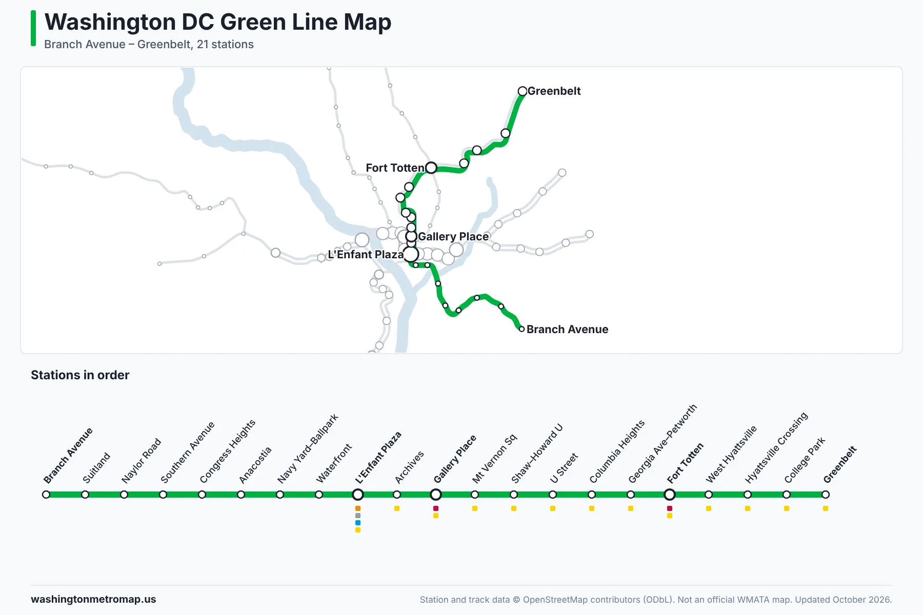
- Branch Avenue
- Suitland
- Naylor Road
- Southern Avenue
- Congress Heights
- Anacostia
- Navy Yard–Ballpark
- Waterfront
- L'Enfant Plaza (Orange, Silver, Blue, Yellow)
- Archives (Yellow)
- Gallery Place (Red, Yellow)
- Mt Vernon Sq/7th St–Convention Center (Yellow)
- Shaw–Howard U (Yellow)
- U Street (Yellow)
- Columbia Heights (Yellow)
- Georgia Ave–Petworth (Yellow)
- Fort Totten (Red, Yellow)
- West Hyattsville (Yellow)
- Hyattsville Crossing (Yellow)
- College Park–U of Md (Yellow)
- Greenbelt (Yellow)
How to Use the Interactive DC Metro Map
- Zoom and move the map. Scroll with the mouse wheel or pinch on a phone to zoom, and drag to move. The buttons on the right zoom in and out, re-center on your station or route, reset the view and open full screen. With the map focused, the arrow keys move it and the plus and minus keys zoom.
- Find a station. Type part of a name in the search box, such as "gallery" or "airport". Former names and nearby landmarks also work, for example "White Flint" or "Nationals Park". Choose a result to zoom to the station and open its details.
- Show or hide lines. Use the switch next to each line to show or hide it, or the frame button to zoom to that line. Hiding lines makes busy downtown sections easier to read.
- Plan a route. Open the Plan a route tab and choose a starting station and a destination, or select them on the map. The planner follows the real track connections and shows which trains to take, the direction to ride, where to change trains and the number of stops. The swap button reverses the trip.
- Spot transfer stations. Transfer stations have larger station circles with a heavier outline. On a planned route, the start has a bold ring and the destination is a solid circle.
- Share a station or trip. The page address updates as you select a station or plan a route, so you can bookmark it or send the link to someone.
Major Washington DC Metro Stations
- Metro Center
- Red LineOrange LineSilver LineBlue LineA major transfer point where the Red Line meets the Orange, Silver and Blue lines here, in the middle of downtown Washington.
- Gallery Place
- Red LineYellow LineGreen LineTransfer between the Red Line and the Green and Yellow lines, serving Chinatown, Penn Quarter and Capital One Arena.
- L'Enfant Plaza
- Orange LineSilver LineBlue LineYellow LineGreen LineThe only station served by five lines: Orange, Silver, Blue, Green and Yellow. Virginia Railway Express commuter trains stop at the separate L'Enfant VRE station nearby.
- Union Station
- Red LineRed Line station at Washington Union Station, with connections to Amtrak, MARC and VRE trains, close to the U.S. Capitol.
- Smithsonian
- Orange LineSilver LineBlue LineOpens onto the National Mall and is the closest station to many Smithsonian museums and the Washington Monument.
- Ronald Reagan Washington National Airport
- Blue LineYellow LineServed by the Blue and Yellow lines, with walkways connecting the station to the airport terminals.
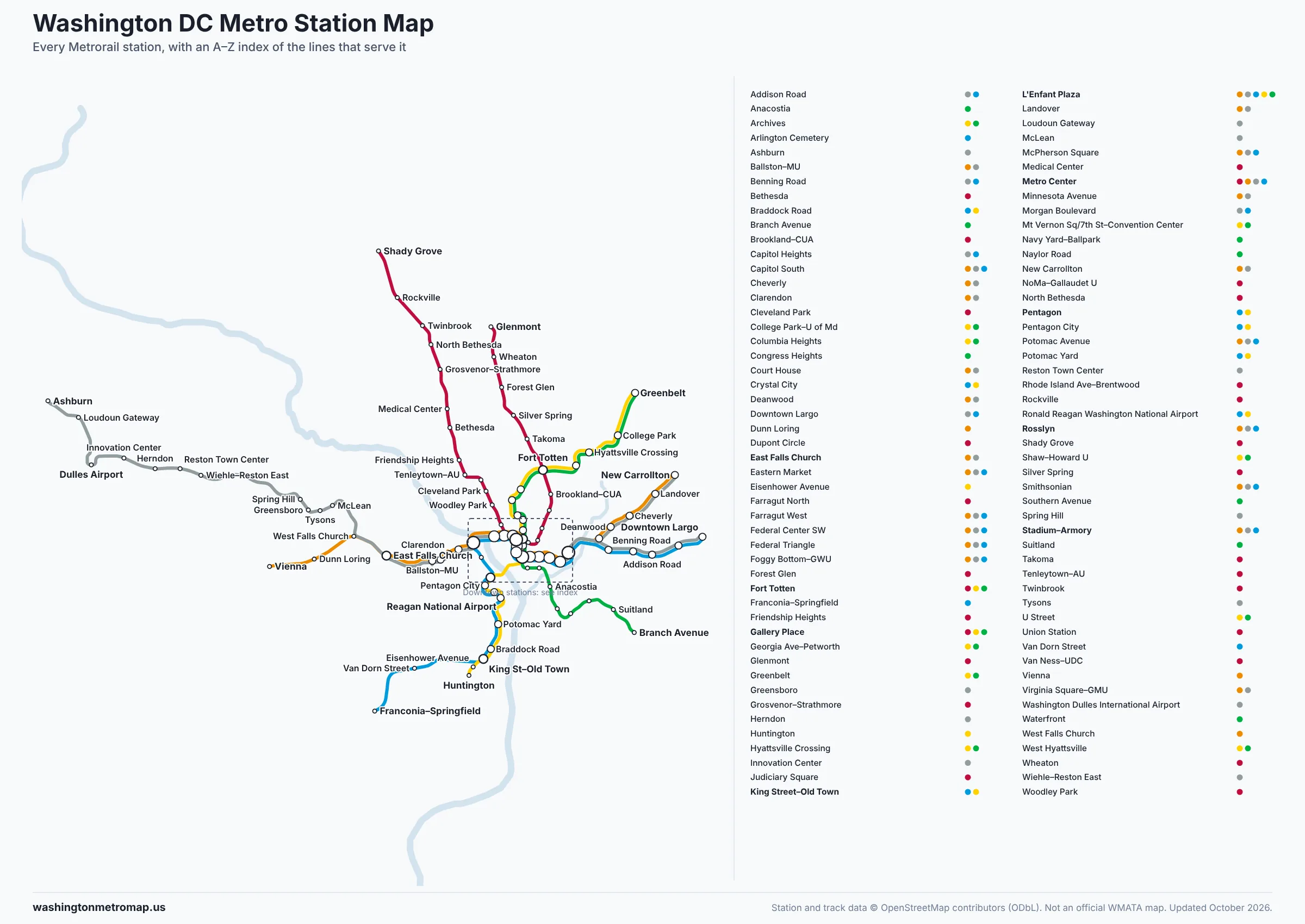
Washington DC Metro Map PDF
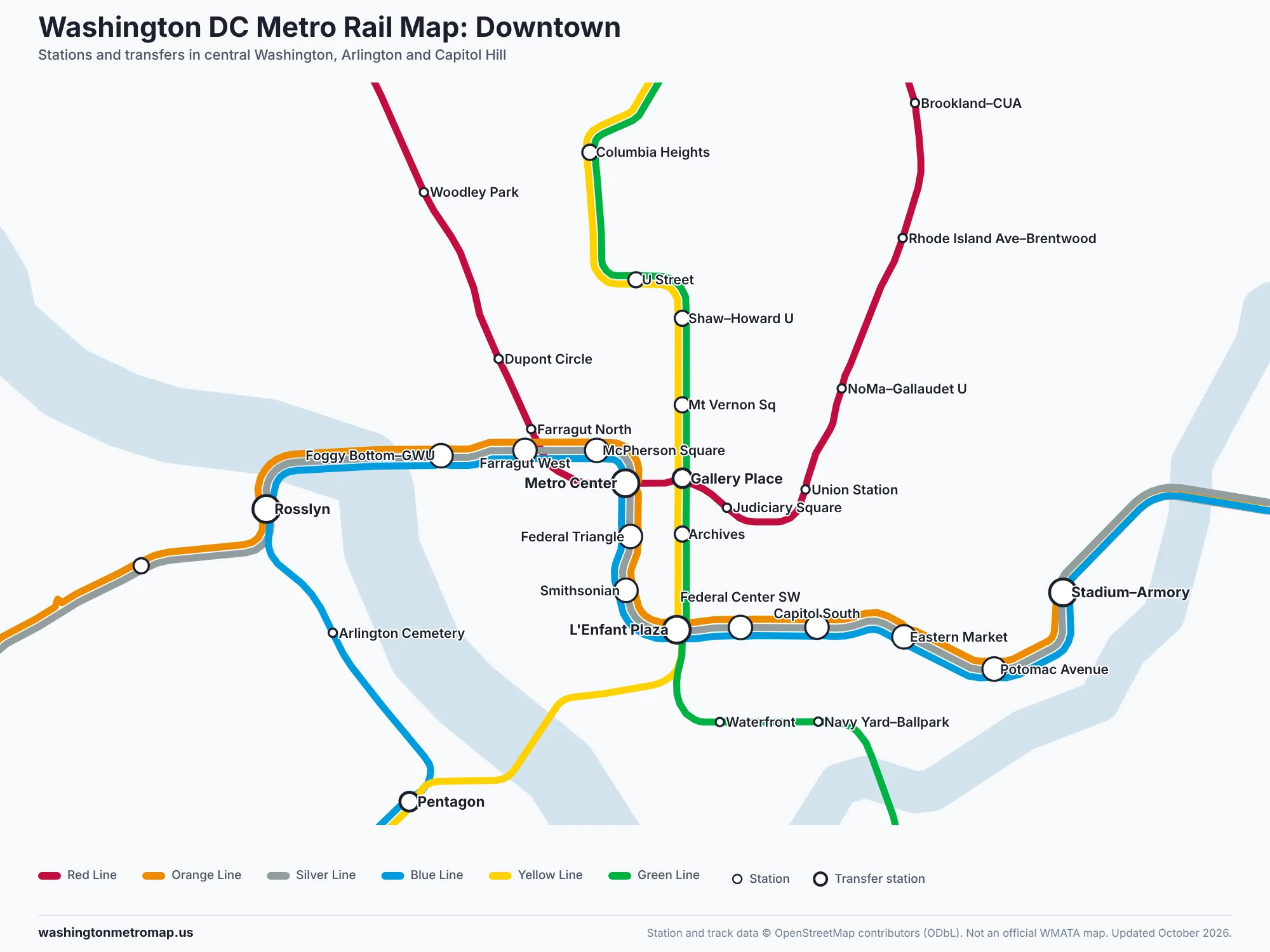
A printable version of the system map, drawn for this site from the same station and track data as the interactive map. It includes every station, all six lines, transfer stations and a downtown inset.
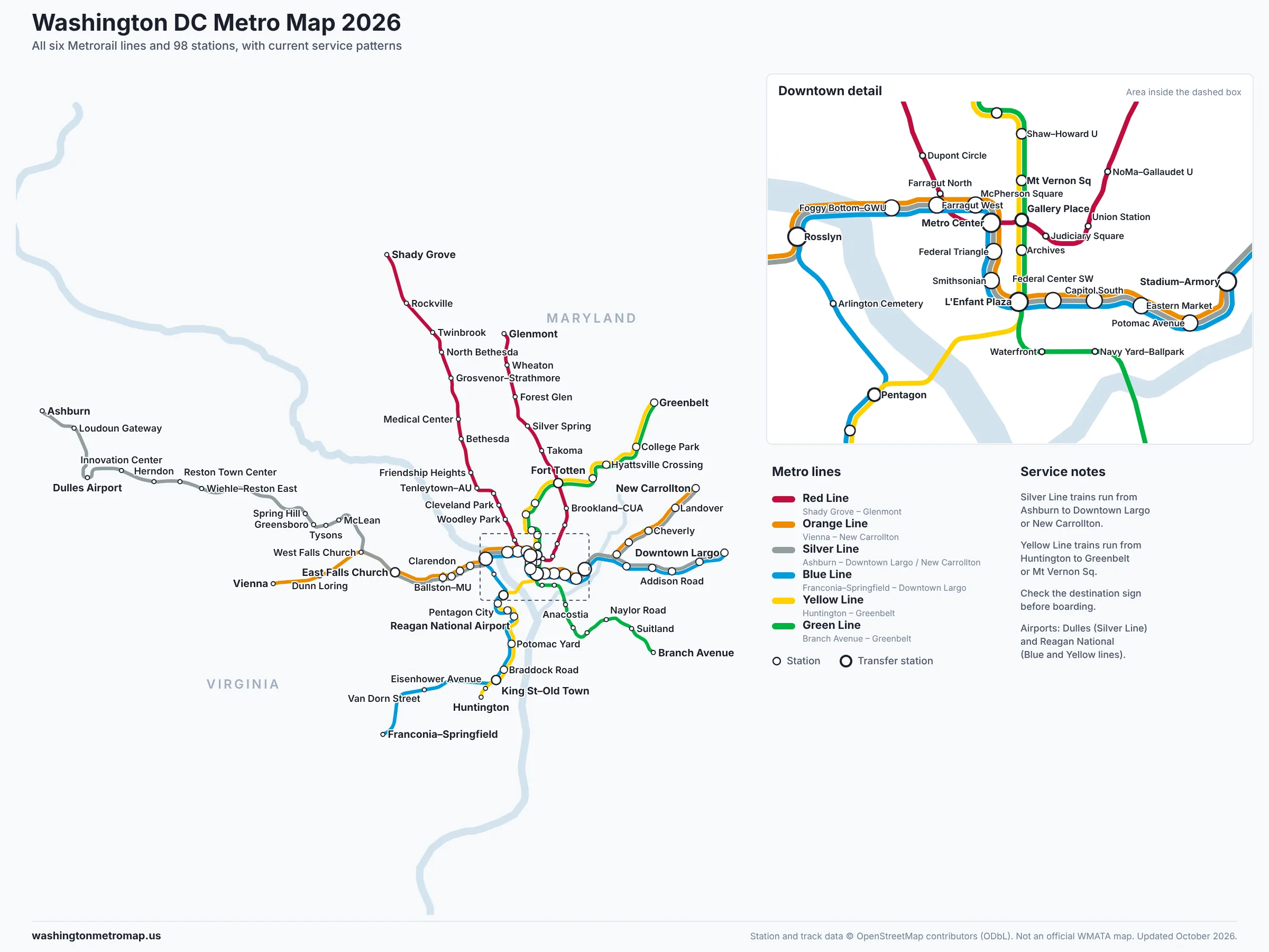
Download the PDF (981.2 KB)Download high-resolution PNG
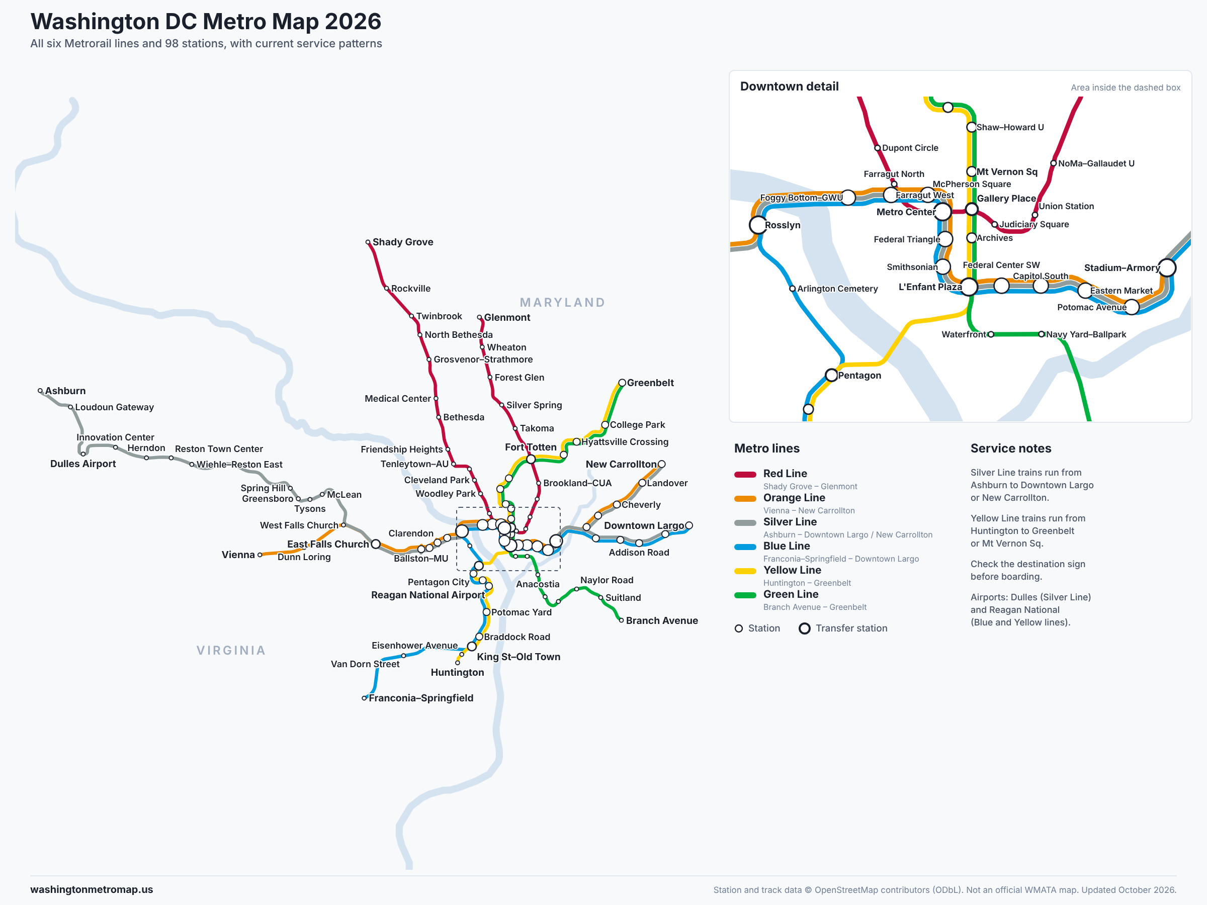
More Metro map images
Frequently Asked Questions
How many lines are on the Washington DC Metro?
Metrorail has six lines: Red, Orange, Silver, Blue, Yellow and Green. Together they serve 98 stations in Washington, DC, Maryland and Virginia. Several lines share tracks through downtown, so many stations are served by two or three lines.
How do I find a Metro station?
Type a station name, part of a name or a nearby landmark into the search box above the map. Choose a result to zoom to the station and see which lines stop there. You can also browse the full station lists for each line on this page.
Which Metro station connects to Dulles Airport?
Washington Dulles International Airport station is on the Silver Line, between Innovation Center and Loudoun Gateway. It opened in November 2022. Silver Line trains run from the airport through Reston, Tysons and Arlington into downtown Washington.
Which Metro lines go to Reagan National Airport?
Ronald Reagan Washington National Airport station is served by the Blue and Yellow lines. From downtown, the Yellow Line is usually the more direct choice because it crosses the Potomac directly from L'Enfant Plaza to the Pentagon.
How do I change Metro lines?
Get off at a transfer station such as Metro Center, Gallery Place, L'Enfant Plaza, Fort Totten, Rosslyn, Pentagon, King Street–Old Town, East Falls Church or Stadium–Armory, then follow the signs for your next line and direction. You do not need to tap your card again while you stay inside the fare gates. The route planner tells you exactly where to change.
Where do Silver and Yellow Line trains end?
Silver Line trains run from Ashburn to either Downtown Largo or New Carrollton. Yellow Line trains run from Huntington to either Greenbelt or Mt Vernon Sq. Always check the destination shown on the train and the platform sign.
Can I use the interactive DC Metro map on my phone?
Yes. On a phone the map fills the screen and the search, line switches and route planner sit in a panel you can pull up from the bottom. Pinch to zoom, drag to move, and use the full-screen button for more room.
Station locations and track geometry © OpenStreetMap contributors, available under the Open Database License. Line service patterns checked against WMATA service announcements; data updated October 30, 2026. This site is not affiliated with WMATA. Service changes, track work and closures are announced on wmata.com.