Looking for the most updated Washington Metro Map PDF ? You’re in the right place. Whether you’re a tourist visiting the U.S. capital or a local commuter, having a clear, easy-to-read metro map at your fingertips is essential. On this page, you can download the latest 2025 Washington Metro Map in PDF format — completely free.
Washington DC Metro Maps – All PDF Downloads
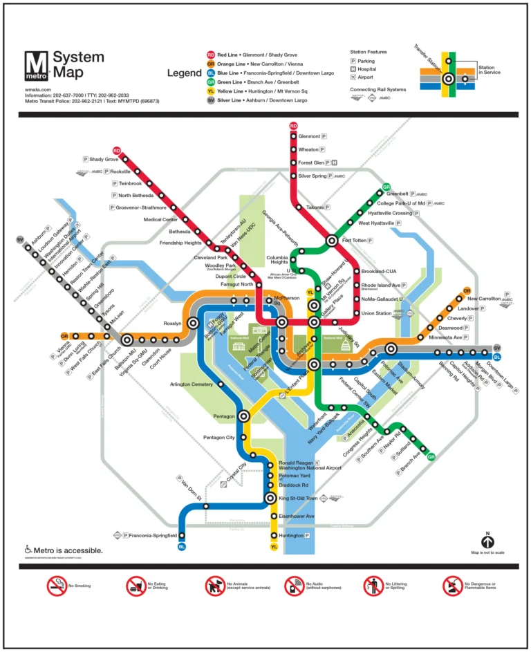
Download updated, printable Washington DC Metro maps including streets, overlays, hotels, and standard rail maps.
Washington DC Metro Rail Map PDF
High-resolution Washington DC Metro Rail map in PDF format showing all metro lines and stations.
Download Rail Map PDFDC Metro System Map (Printable)
Printable DC Metro system map ideal for commuters, tourists, and offline travel planning.
Download Printable PDFWashington DC Metro Map with Streets
Metro map integrated with major Washington DC streets for easier navigation.
Download Streets PDFDC Metro Map Overlay PDF
Overlay version of the DC Metro map aligned with the city layout and landmarks.
Download Overlay PDFWashington DC Metro Map with Hotels
Tourist-friendly metro map highlighting hotels near metro stations.
Download Hotels PDF🗺️ What’s New in the 2026 Washington Metro Map?
The Washington Metropolitan Area Transit Authority (WMATA) has introduced some important updates for 2025, including:
- New station names and updates
- Expanded service lines and extensions
- Accessibility improvements
- Clearer color-coded routes
These updates make it easier for passengers to navigate all six metro lines: Red, Blue, Orange, Silver, Yellow, and Green.
The map includes:
- All Metro stations
- Line connections and transfers
- Airport access (DCA, IAD)
- Icon guide for accessibility and services
You can print it out, save it on your phone, or share it with friends.
🚇 Why You Need the Metro Map
The Washington Metro system serves millions of riders every year across D.C., Maryland, and Virginia. Having the latest map helps you:
- Plan your commute
- Avoid delays by checking alternate routes
- Save time during transfers
- Navigate the city like a local
🔍 Pro Tips for Using the DC Metro
- Use a SmarTrip Card to save on fares
- Avoid peak hours (7–9 AM and 4–6 PM)
- Download the WMATA app for real-time updates
- Watch for weekend schedule changes